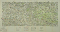
In March 1918, after years of trench-war stalemate on the WWI Western Front in France and Belgium, the German Army made a sudden breakthrough of the Allied lines. They made rapid advances but these were essentially a last-gasp effort of an exhausted army. By July of 1918, (the date of the map), they were retreating, although in good order and still fighting fiercely. The map shows the general theater of operations in these last crucial four months of what, up to then, was the largest and deadliest war in human history. A key factor in the changed situation was the entry into the war by the USA. The US Army, under six-star General John Pershing, was especially involved in the last battles of this terrible conflict. This included the engagement called, variously, the Battle of Meuse-Argonne or the Argonne Forest. This conflict lasted from September 16th to November 11th 1918; at which latter date, an Armistice was declared, (“All Quiet on Western Front”), and the war effectively ended. More than 1,000,000 Americans participated in these battles, among them, Harry Truman, an artillery captain and later the President of the United States, and the great American hero, Sergeant Alvin York, a famed marksman, who won his Congressional Medal of Honor on October 8th, for single-handedly neutralizing an entire German battalion and taking 132 prisoners.
France, Armée Groupe de canevas de tir.
108 x 77 cm. Printed at Base Printing Plant 29th Engineers U.S. Army, 1918 (full map, left; detail, right)
Richard Edes Harrison was a Yale architecture graduate who was a gifted illustrator. His graphic talents eventually became centered on cartography and he published his first map for Time magazine in 1932. He worked, variously as a freelance artist, a staff-member for national magazines, as a government cartographic consultant and a visiting lecturer at several universities. His most noteworthy cartographic talent was his innovative use of global perspectives. His ingenuity lay in compiling these viewpoints by combining, in various ways, geometry, geography and imagination, plus his own individual approach to selective exaggeration. The overriding notion was to serve the map-reader. That is, to give them a new, stimulating and, ultimately greater understanding of geographical and political situations. His work came to notable fruition in a series of maps made for Fortune magazine, starting in 1940 before the US entry into war. His characteristic signature was his expansion of the bird’s-eye view format to worldwide settings. In particular, his use of novel orientations and the so-called over-the-horizon approach could be quite startling for an audience wedded to “north is up” conventions. His maps were well-received and the best were published as a noted collection in 1944 as, “Look at the World: The Fortune Atlas for World Strategy”
Richard Edes Harrison
Orthographic Series III
Ortographic Projection
1942


