

Views of towns and cities may have been the most popular category of printed images in nineteenth century America. They have also been known as bird’s eye views, perspective maps and aero views. Although not drawn to scale, they show street patterns, buildings and major landscape features. These views hung in homes and businesses. They represented for many Americans in the nineteenth century the result of industrial development and of rapid economic growth and prosperity. City views compressed commerce and industry into neat, decorative scenes reflecting the well-being of Victorian America. Panoramic maps graphically depict the vibrant life of a city. Busy harbors speeding trains, factories and people on the move were vividly portrayed. Advances in the field of lithography made it possible to produce multiple copies of a view. For a suitable fee, the map artist would include illustrations of private homes in the main city plan thereby allowing a proud citizen to point to his property or business on the map. The most prolific artists and publishers of views were Thaadeus Mortimer Fowler, J.J. Stoner, George Norris, George Walker and Albert Ruger.
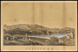
F. B. Ladd
Augusta, ME
Colored lithograph, 30 x 44 cm.
New York: Printed by F. Heppenheimer, 1854
Osher Collection

G.H. Matthews
Augusta in 1823
From a painting by Cyril Searle, 16 x 24 cm.,
and from: James North, History of Augusta, Maine, facsimile of 1870 ed. (Somersworth, NH: New England History Press, c 1981)
Augusta, Maine, 1823
Osher Collection

Gina Platt
Maine State Capitol building, St. Augustine Catholic Church and Fort Western
Colored photographs
Augusta, Maine, 2004
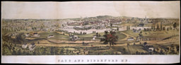
John Badger Bachelder
Saco and Biddeford Me.
Colored lithograph, 29 x 82.5 cm.
Boston: John Henry Bufford, ca. 1855
Osher Collection

Artist Unknown
Waldoboro, Lincoln County
Lithograph, 33 x 59 cm.
Source unknown, 1896
Osher Collection
Gina Platt
Pepperell Manufacturing Company, Biddeford;
German Meeting House, Waldoboro
Colored photographs
Maine, 2004
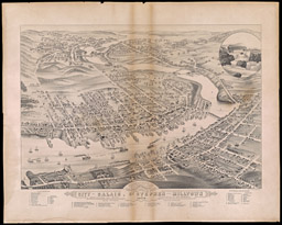
J. J. Stoner
City of Calais, St. Stephen and Milltown Washington Co. Charlotte Co. New Brunswick 1879
Lithograph, 50.2 x 65.9 cm.
Madison, Wisconsin, 1879
Osher Collection
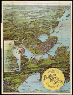
Walker & Lith. & Publ. Co.
Birds Eye View Showing Portland R.R. Co. System and Connecting Lines
Color lithograph, 69.5 x 52 cm.
Boston, Copyright, 1909.
Osher Collection
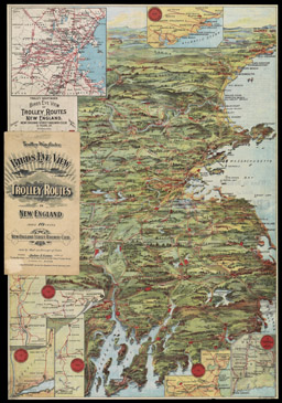
Trolley Wayfinder
Birds Eye View of Trolley Routes In New England
Color lithograph, 51 x 36 cm.
Boston: New England Street Railway Club, ca. 1906
Osher Collection