

Ocean travelers used maps in variety of ways. When planning their trip, they could see which ports were most convenient to their final destinations. While in transit, the ship’s position was publicly posted every day and passengers were invited to plot their vessel’s course in an abstract log [137]. Companies also ensured that their customers could find their way easily from their port of debarkation to their ultimate destination.
The International Mercantile Marine conglomerate produced an especially effective map [139] showing train times and prices (for both first- and second-class passengers) between various ports and cities across Europe. But only the Canadian-Pacific Line could boast of an integrated network of ships and railroads that spanned the Atlantic, North America, and the Pacific [138].
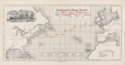
Dampfer: Lahn (1888-1904), Capt. H. Hellmers.
Abge-fahren: Sandy Hook 2/7 1890, 6h 8m on Angekommen: Needles 10/7, 5:30 a.m. 1890.
Abstract log. 20 × 41cm.
Morse Collection, 2566.
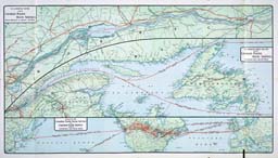
Map from a brochure entitled “The Canadian Pacific Ocean Services Limited: Atlantic Ser-vice,”
1910. 46.5 × 81 cm.
Morse Collection, 1737

“Map of Europe with Information for Ocean Travelers, Containing Particulars of the American, Atlantic Transport, Dominion, Leyland, Red Star, White Star, White Star-Dominion Steamship Lines.”
1912. 72 × 62 cm.
Morse Collection, 2856