Maps have been used as wall decorations since ancient times. In some instances, they were painted directly on walls, while in others they were created on materials such as stone, wood, animal hides, or fabric and were then attached to walls. Large medieval world maps known as mappae mundi often decorated public buildings and religious institutions. Among surviving Italian Renaissance art treasures are mural maps in the Vatican Palace, the Doge's Palace in Venice, and the Palazzo Vecchio in Florence. During the sixteenth and seventeenth centuries, tapestry maps were woven in Flanders and England. The most famous of these, a set of ten great tapestry maps celebrating the defeat of the Spanish Armada, hung in the House of Lords for more than two centuries until their destruction in the great fire of 1834.
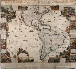
The development of printing greatly increased the availability of wall maps. Printed from multiple woodblocks or engraved copper plates, individual sheets were joined to form wall maps and were then mounted for framing or backed with cloth and attached to rods for hanging. Such maps reached the peak of their popularity in the Netherlands in the sixteenth and seventeenth centuries, a time of expanding colonial empire and great interest in exploration-Appreciated as works of art and as symbols of success, they found great favor as wall hangings in public buildings, places of business, and homes of affluent merchants and burghers. This may be seen in Dutch paintings of the period, especially those of Vermeer. At the end of the seventeenth century, leadership in the production of wall maps passed to the French; the two wall maps seen here are of French origin and exemplify the extensive geographic detail and elaborate ornament made possible by their large size.
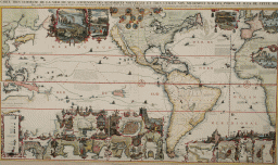
The number of surviving wall maps is small because many were destroyed by exposure to light, variations of temperature and humidity, pollution, handling, and general wear and tear. A few have been preserved in good condition by being bound in giant atlases or, as in the case of the Chatelain map shown here, by being bound in sections, or folded, or both.
This is one of the earliest original French wall maps of the Americas, and represents the vanguard of the French takeover of such productions from the Dutch. The geography is presented in great detail, reflecting the extensive French explorations of the interior of North America. French territorial claims are asserted by applying the place name "La Louisiane" to the entire Mississippi Valley and "Canada ou Nouvelle France" to all of eastern North America except for the extreme southeast and a narrow zone along the northeastern shore. California is portrayed as an island in accordance with the best geographic thinking of the time.
The composition of this map represents a departure from the traditional Dutch carte a figure design. Instead of the formal paneled borders consisting of stylized costumed figures, city views, and allegorical themes, De Fer has created border vignettes of variable size and shape, sometimes intruding into the map area, especially at the corners. The scenes are rendered in considerable detail and are accompanied by lengthy explanatory legends. They depict a cross-section of natives and their cultures, panoramic views, and various scenes emphasizing natural resources and commercial enterprises such as cod fishing, chocolate making, mining, sugar production, and forestry. The most intriguing vignette portrays a colony of beavers busily engaged in building a dam, with Niagara Falls in the background; details of this scene are presented in the next item.
Nicolas de Fer (French, 1646-1720)
L'Amerique, divisée selon l'etendue de ses principales parties (Paris, 1698/1705)
Engraving and etching, hand colored
Osher Collection
Items 22 and 23 illustrate another example of plagiarism. The original beaver scene from the De Fer wall map (item 22) and the copy by Chatelain (item 23) are essentially identical except for the absence in the Chatelain copy of letters identifying the various beaver "occupations."
In this charming scene beavers are endowed with many human qualities but retain their beaverish work ethic in conducting a highly organized dam-building enterprise. Many stand upright and form a production line with specialized duties assigned to each member. The De Fer legend describes "woodsmen" (A) in the lower right felling a large tree with their teeth, "carpenters" (B) in the right foreground trimming branches, a "porter" (C) in the center foreground carrying branches to the construction site, "mortar makers" (D) at the water's edge on the right, "mortar carriers" (G) along the top of the dam hauling mortar on their tails, and "masons" (I,L) atop dam at left building the dam and packing the mortar by tapping with their tails. One unfortunate beaver (H) lies supine at right center from "having overworked his tail," and is being ministered to by "inspectors of the sick" (F). In the background, a "commandant or architect" (E) supervises the entire project
This map is extraordinary from two standpoints: its great beauty and the vast amount of information it conveys. Although its geographic coverage extends from the Pacific coasts of Asia and Australia to the Atlantic coasts of Europe and Africa, its focus is clearly on the Americas. California is portrayed as an enormous island with rather tentative northern borders; a superimposed legend notes that some "moderns" believe it to be connected to the mainland. There are numerous historical notes and tracks of explorers' routes across the oceans.
The most striking feature of this map is its lavish decoration arranged for the most part around the borders in an intricate mosaic-like pattern. Individual decorative elements are in the form of geographic insets, city plans, panoramas, bird's-eye views, miniature portraits, and vignettes of various sorts, separated by delicate rococo borders. Here again, color is effectively used to clarify and render the map more "readable." While it is clear that artistic effect was a primary consideration, the detailed and authentic images are rich in geographic, historic, ethnographic, cultural, and ecologic content; some are frankly commercial or political in nature. Among the more notable images arrayed across the top and down the right side are a beaver colony (copied from De Fer), an Indian hunting scene, medallion portraits of explorers with brief biographies on banners, the codfish industry (also copied from De Fer), and views of the Strait of Gibraltar and the Cape of Good Hope (the only two non-American decorative images on the map). Across the bottom is an encyclopedic collection of images, including numerous views and plans of cities and harbors of the New World, vignettes of an Aztec temple and ritual sacrifice, a sugar mill and silver mine, and scenes of native customs and rites. Depictions of exotic trees, fruits and vegetables, and birds are used to form or embellish demarcations between scenes.
Henri Chatelain (French, 1684-1743)
Carte tres curieuse de la mer du Sud. From, Atlas Historique (Amsterdam, 1719)
Engraving, hand colored
Osher Collection
Maps of the Low Countries in the form of a lion are undoubtedly among the most decorative in the history of cartography. The title "Leo Belgicus" (Lion of Belgium) uses the name Belgium to designate the Seventeen United Provinces of the Netherlands, an area which now encompasses Holland, Belgium, and Luxembourg. The design was conceived by Michael Aitsinger in 1583 as an illustration for his book on the history and topography of the Low Countries. The lion had long been used as a symbol of strength and appeared on the coats of arms of almost all of the provinces of the early Netherlands. Aitsinger's design captured the imagination of historians and mapmakers and was widely copied, sometimes with modifications. It eventually achieved the status of a patriotic national emblem during the long struggle for independence from Spain. The version shown here is one of the most attractive, with the finely engraved majestic lion unobtrusively superimposed on the geography; other embellishments include heraldic crests of the provinces, a sea monster, sailing ships, and costumed figures illustrating the dress of inhabitants of various regions, ages, and social strata.
Pieter Kaerius (Dutch, 1571-1646)
Leo Belgicus. From, Germania Inferior (Amsterdam, 1617)
Engraving, hand colored
Osher Collection
This diminutive version of Leo Belgicus was created by Famiano Strada to serve as frontispiece for an edition of his history of the Belgian Wars. There are minor changes from the larger version by Kaerius: the raised forepaw now rests on a shield bearing the book title, a decorative compass rose has been inserted into the bend of the lion's tail, the sea monster and sailing ships are different, and the heraldic crests and costumed figures are lacking. This is an especially fine example of early hand coloring with gold highlights.
Famiano Strada (Italian, active 1632-1640)
[Leo Belgicus]. From, De Bello Belgico (Antwerp, 1648)
Engraving, hand colored with gold highlights
Osher Collection


