
Some, to beautify their Halls, Parlors, Chambers, Galeries, Studies, or Libraries . . . liketh, loveth, getteth, and useth, Maps, Charts and Geographicall Globes. John Dee (about 1570)
Maps are graphic representations or images of the earth or heavens, or parts thereof. As pictures of the earth they are analogous to landscape paintings. The problem of depicting a three-dimensional world on a flat surface is common to both maps and conventional art and is addressed by the same mathematical approach, called "projection" by mapmakers and "perspective" by artists.
Maps and conventional art are both created by many of the same processes, including drawing, painting, woodcut, engraving, etching, and lithography. Both forms of graphic art have historically been produced in the same workshops and by the same craftsmen. A "text book" for artists, published in London in 1769, was titled, "The Art of Painting in Oyl, to which is added the whole art and mystery of colouring maps."
A number of maps have been created by recognized artists, including Leonardo da Vinci and Albrecht Dürer. The first three maps in this exhibition were made by individuals who are better known as artists than as mapmakers.
This remarkable woodcut was made in the workshop of Master Michael Wolgemut and Harms Pleydenwurff, teachers of Albrecht Dürer. It embodies western-European geographic concepts at the time of the first Columbus voyage, a mixture of medieval dogma and legend and emerging Renaissance science. It presents the last popular image of the world before the explosion of new geographic information generated by the Age of Discovery. The outmoded geography retains the second-century world configuration of Claudius Ptolemy, remarkable for its land-locked Indian Ocean. The borders of the map contain twelve wind-blowers or "wind-heads," traditional decorative symbols with names corresponding to wind directions; on later maps these were replaced by ornamental circular "windroses," and ultimately by compass roses. [See maps 8, 10 & 12] Old Testament influence is seen in the depiction of Noah's three sons, Japhet, Shem, and Ham, apparently contemplating their assigned task of repopulating the earth following the Great Flood. Perhaps the most striking feature is the depiction of grotesque humanoid monsters - representing lingering medieval superstitions about inhabitants of unexplored geographic regions.

Hartmann Schedel (German, 1440- 1514)
Secunda etas mundi. From, Liber cronicarum (Nuremberg, 1493)
Woodcut
Osher Collection
This is the only known map made by Antonius Florianus, a distinguished Venetian painter and architect. Florianus dealt in a unique fashion with the difficult problem of accurately portraying the spherical earth on a flat surface. Using Mercator's 1538 world map as a model, Florianus divided each hemisphere into thirty-six elongated triangular sections ("gores"). The result is a strikingly beautiful "sunburst" design with minimal geographic distortion. Although it would be possible to create a globe by dissecting and mounting the gores, this was probably not the artist's intent, as evidenced by the elegantly engraved panels and corner medallions. The map is untitled and unsigned; the upper right medallion contains a self-portrait of the artist, however, perhaps in lieu of a signature.

Antonius Florianus (Italian, active 1545-1555)
Untitled Double Hemisphere World in Gores (Venice, about 1555)
Engraving
Osher Collection
It is generally believed that this map was produced through the collaborative efforts of cartographer Sebastian Münster and artist Hans Holbein the younger. Published forty years after the first Columbus voyage, the geography is already outdated: the Pacific Ocean is far too small; Japan ("Zipangri") is only a short distance west of North America ("Terra de Cuba"); and a strait separates North and South America — four hundred years before the Panama Canal! The oceans are embellished by sea monsters, a mermaid, and a galleon, representing one of the earliest uses of such fanciful images on a printed map. It is the highly decorative borders, however, that distinguish this map as one of the most interesting of the sixteenth century. Exotic scenes reflect the prevalent European misconceptions about other continents and their inhabitants, with vivid portrayals of cannibals at work, winged monsters, hunting scenes, and natives with large deformed lips. Most fascinating of all are the angels at the North and South poles, busily cranking the earth around on its axis - eleven years before Copernicus published his theory of the solar system.
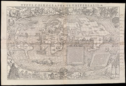
Sebastian Münster (German, 1489-1552)
Hans Holbein (German, 1497-1543)
Typus Cosmographicus Universalis. From, Johann Huttich and Simon Grynaeus, Novus Orbis Regionum (Basel, 1532)
Woodcut
Osher Collection