
Records of early voyages of exploration consisted primarily of narrative accounts and descriptions contained in ships' logs, supplemented by hand-drawn charts of the waters, navigational landmarks and hazards, and coastal features. Sketches of birds, animals, vegetation, natives, habitations, and settlements were sometimes made by the captain or other members of the expedition, often as an incidental and unofficial activity. Unfortunately, these original records were frequently lost; those that survived served as source materials for professional cartographers, usually land-based, who created the finished maps and charts.
In later years it became customary to include trained artists as members of exploratory groups. One of the first such artists, Jacques Le Moyne, was a member of the French expedition to Florida in 1564. His paintings included a map of Florida and adjacent areas, and depictions of activities of the French colonists and the Indian natives. After Le Moyne's death, his paintings were acquired by Theodor de Bry, who made engraved copies of them to illustrate his published account of Le Moyne's narrative of the French colony. Only one of Le Moyne's paintings has survived, and his work is now known almost exclusively through the de Bry derivatives.
John White, an accomplished artist, was a member of the first English expedition to Roanoke in 1585, and governor of the second expedition under the sponsorship of Sir Walter Raleigh. His watercolor drawings comprised two maps, numerous portrayals of the Algonquian Indians, their habitations, villages, and customs, and pictures of indigenous fauna and flora. Twenty-three of these watercolors were copied by de Bry as engraved illustrations for his edition of Hariot's^4 Brief and True Report of the New Found Land of Virginia, published in 1590. The original watercolors were rediscovered in 1865 and are preserved in the British Library. It is through the widely distributed de Bry volumes, however, that the images came to public attention and were reproduced on maps and other publications.
This beautifully executed map exemplifies many of the attributes of the great Dutch maps: accurate geography, artistic composition, fine engraving, elegant lettering, attractive decorative imagery, and skillful hand coloring. Production of maps such as this was a complex process involving several steps:
- Geographic information from earlier maps or from descriptions by explorers and travelers was carefully compiled to create a new geographic delineation.
- Decorative elements were created, adapted, or borrowed; many of the images and motifs were taken from pattern and emblem books, illustrated travel and voyage accounts, or other works of art. In some cases, they were simply copied directly from other maps, along with the geography.
- The above elements were integrated into an overall design, engraved on a copper plate, and printed
- Hand coloring was applied (optional).
Displayed here is the major source for the geographical portion of this map, together with the sources for some of the decorative elements.
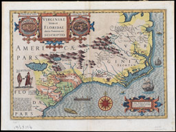
Jodocus Hondius (Flemish, 1563-1612)
Virginiae item et Floridae Americae Provinciarum, nova Descriptio (Amsterdam, 1606)
Engraving, hand colored
Smith Collection
This pen and ink and watercolor drawing was the primary source for the northern portion of the map, while the southern portion was largely based on a drawing by the French artist Jacques Le Moyne. The same two sources were used by de Bry for his separate maps of Virginia and Florida, respectively.

The original exhibition displayed a color laser photocopy of collotype and stencil reproduction of John White's pen-and-ink and watercolor map, entitled "La Virgenia Pars" (London, about 1588), published in facsimile by The Trustees of the British Museum (London, 1964), from the Smith Collection. Because this facsimile remains in copyright, the large thumbnail connects (as of March 2014) to the Prints and Drawings department of the British Museum, London.
This is the engraved version of a painting by Le Moyne, depicting an Indian king and queen taking an evening walk, accompanied by their retinue. It typifies European artistic style of the period and illustrates the then-prevalent concept of American Indians as "noble savages," portraying their bearing and physiques in a classical style. With appropriate dress, this grouping could be mistaken for a European court scene.

Theodor de Bry (Flemish, 1528-1598)
Regis & Regina prodeambulatio recreandi animi gratia. From, Brevis Narratio Eorum quae in Florida Americae (Frankfurt, 1591)
Engraving
Smith Collection
This watercolor of a palisaded Indian village served as the model for the engraving in the de Bry book.

The original exhibition displayed a color laser photocopy of collotype and stencil reproduction of John White's pen-and-ink and watercolor drawing, entitled "The towne of Pomeiock" (London, about 1588), published in facsimile by The Trustees of the British Museum (London, 1964), from the Smith Collection. Because this facsimile remains in copyright, the large thumbnail connects (as of March 2014) to the Prints and Drawings department of the British Museum, London.
A miniature copy of this engraving is seen to the right of the title cartouche, with its Le Moyne counterpart on the left. These images were used repeatedly on maps of eastern North America throughout the seventeenth century.
Theodor de Bry (Flemish, 1528-1598)
Oppidum Pomeiooc. In: Admiranda Narratio (Frankfurt, 1590-92)
Smith Collection
This watercolor illustrates the methods and equipment used by the Indians for catching fish. Representations of aquatic creatures are accurate enough to identify many of them, such as the horseshoe crab and the hammerhead shark. The most engaging image is that of the dugout canoe labeled "A Cannow," with Indians standing fore and aft and two more crouching over a small fire in the middle. It is believed that the fire was used during nocturnal "torchlight fishing" to attract fish which were then speared from the canoe. A miniature engraved form of this image was used to embellish numerous maps, including several others in this exhibition.

The original exhibition displayed a color laser photocopy of collotype and stencil reproduction of John White's pen-and-ink and watercolor drawing, entitled "The manner of their Fishing" (London, about 1588), published in facsimile by The Trustees of the British Museum (London, 1964), from the Smith Collection. Because this facsimile remains in copyright, the large thumbnail connects (as of March 2014) to the Prints and Drawings department of the British Museum, London.