
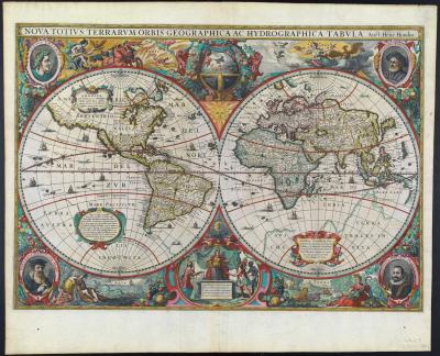
This beautifully engraved map appeared in an early Dutch book on navigation to the East and West Indies, and its imagery is a complex mixture of allegory and natural history. It is one of the first printed maps of the world to include allegorical vignettes around both hemispheres. The border decorations consist largely of personifications of the continents, set against landscapes depicting their respective terrains, fauna, flora, and scattered inhabitants. At the upper left, seated on a globe and bearing a scepter and cornucopia, Empress Europa surveys a coastal scene with an offshore fleet, mountaintop castles, various domestic animals, and wild bears. Across from Europe sits Asia, holding a censer and seated on a camel, with a European-style church and castle in the background. A giraffe and rhinoceros are illustrated nearby, displaced from their normal habitat. At the lower left, America is seated on an armadillo, holding an arrow and a European style battle-ax. Behind her are Native Americans hunting and engaging in cannibalism. Africa, seated on a crocodile at the lower right, holds a snake in her left hand and, in her right, a leafy branch, likely a sprig of balsam to represent tribute.
The geography of the map shows updated details based on recent English voyages and the description of Japan by Portuguese cartographer Luiz Teixeira. The map also turns Willem Barentsz’s Novaya Zemlya (see map #4) into an island with an open sea representing the North-West Passage between it and the Arctic.

Petrus Plancius
Jan Baptista Vrients
Orbis terrae compendiosa descriptio ex peritissimorum totius orbis gaegraphorum operibus desumta : Antverpiae apud Joanem Baptistam Vrient
Antwerp, 1596
Osher Collection
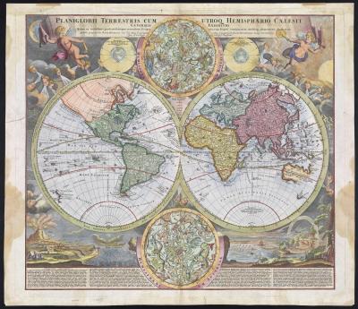
This double-hemisphere map of the world is embellished with twenty-six decorative scenes, including scientific projections of the Celestial skies and contemporary astronomical theories. Fourteen of the small circular cartouches feature astronomical views, while the other twelve depict various global views, including those of the poles and an armillary sphere. The border also depicts winds and climates with a panoramic illustration of tempests, earthquakes, tides, and vortices, along with a textual commentary on all of these natural phenomena.
The geography of the map is rich in detail, including most of the coast of Australia, the western coast of New Zealand, and the routes and discoveries of explorers Magellan, Dampier, Tasman, Gaetani, and Chaumont.

Adam Friedrich Zurner, (1679-1742)
Planisphaerium terrestre cum utroque coelesti hemisphaerio, sive diversa orbis terraquei…
Amsterdam, 1700
Osher Collection
One of the masterpieces of the greatest period of Dutch cartography, this map combines accurate-to-date geography with ornate and elaborate designs, creating an image that is both informative and aesthetically pleasing. It depicts recently formulated geographic concepts, both correct and erroneous, such as California as an island. Additionally, the newly established North American colonies are recorded, including “Pleymouth” and Virginia. The beautifully engraved and brilliantly colored borders are rich in symbolism. The four classical elements (fire, air, water, and earth) are personified, as are the continents at the lower center, in a vignette showing Europe as an enthroned queen receiving tribute from the other continents. In the corners are finely engraved miniature portraits of Julius Caesar, Claudius Ptolemy, Gerardus Mercator, and Jodocus Hondius, the mapmaker’s father.
Henricus Hondius, (1597-1651)
Jan Jansson, (1558-1664)
Nova totius terrarum orbis geographica ac hydrographica tabula auct. Henr. Hondio.
From the Mercator-Hondius Atlas
Amsterdam, 1633
Osher Collection
Advances in geographical knowledge are reflected in this map in the rejoining of California to the North American mainland and in the emerging outlines of Australia. Two putti (winged cherubic infants) support the banner title, and numerous ornamental cherubic windheads are responsible for chaotic winds, in contrast to their early Renaissance function of indicating specific wind directions. Celestial hemispheres are present, but the emphasis of the decorative elements is clearly on natural phenomena. Climatic zones are indicated around the circumference of the hemispheres, and prevailing marine winds are shown. The sun, moon, and stars, appropriately colored, occupy the upper corners. Diagrams surrounding the terrestrial hemispheres depict the relationships of sun and earth in summer and winter. All types of natural phenomena are graphically illustrated, including rain, snow, strong winds, lightning, a rainbow, a whirlpool, waterspouts, the ebb and flow of the tides, a flood, an earthquake, and the eruption of Mount Etna.
Johann Baptist Homann, (1664-1724)
Planiglobii Terrestris cum utroq Hemisphaerio Caelesti Generalis Exhibitio : quam ex novissimis probatissinnisque recentium geographorum scriptis concinnatam, multisqss. phaenomenis illustratam publice proponit Io. Bapt. Homann
Nuremburg, 1730
Smith Collection
This gorgeous wall map from the late 17th-century celebrates the successes of the Paris Observatory and the Royal Academy in observing the movements of the planets. Along the top are pictures of Saturn, Jupiter, Mars, Venus and Mercury and two plans of the sun and moon. A large tableau displays gods and goddesses, zodiac figures, winds, and mythological scenes, while the lower part of the map depicts mankind in all his activities. The text around the map explains the meaning behind all the beautifully engraved scenes in the map’s borders.

Nicolas de Fer, (1646-1720)
Mappe-Monde, ou Carte Generale de la Terre, divisee en deux hemispheres suivant la Projection la Plus Commune ou tous les Points Principaux sont Placez sur les Observations de Mrs. de l'Academie Royale de Siences.
1694
Osher Collection
Dedicated to Emperor Leopold I of the Holy Roman Empire this map reflects the way in which 17th-century cartography was enlisted to serve political ends. While the middle sphere of the earth covers the eagle’s body, centered on the Holy Roman Empire, the entire world is embraced by the eagle’s talons, suggesting the wide extent of the Holy Roman Empire to the east and west and alluding to ongoing wars with France and the Ottoman Empire.
The map was originally produced at the behest of astronomer Johannes Kepler to reflect his new calculations of longitude and latitude based on planetary observation. The central meridian runs through the Danish island that was home to the 16th-century observatory of Kepler’s mentor, the astronomer Tycho Brahe. Both Brahe and Kepler received successive appointments as the royal mathematician and astronomer of the Holy Roman Empire.

Philip Eckebrecht
Johannes Kepler, (1571-1630)
Nova Orbis Terrarum Delineatio Singulari Ratione Accommodata Meridiano Tabb. Rudolphi Astronomicarum
Ulm, 1658
Osher Collection
Floriano’s map, based on Gerard Mercator’s double-cordiform map of 1538, shows the world divided into two hemispheres and then further divided into 36 globe gores. However, it is unlikely the map was intended to be constructed as a globe, as the portraits of Floriano and Ptolemy, together with the elaborate strap-work around the borders, would have to be destroyed for that purpose.

Antonio Floriano
Antoine Lafréry, (1512-1577)
Gerhard Mercator, (1512-1594)
[The World]
Venice, 1555
Osher Collection
Coronelli’s maps of the eastern and western hemispheres show the new discoveries made by Abel Tasman in Australia and New Zealand and depict California as an island. Placed along the eastern coast of Asia is a representation of the mythical land bridge, Terra di Iesso, which was thought to link Asia to Alaska. The decorative borders include co-ordinates and descriptions of signs of the zodiac from Coronelli’s Atlante Veneto.

Vincenzo Coronelli, (1650 -1718)
Planisfero del Mondo Vecchio, Descritto dal P. Coronelli, Cosmografo Publico
Venice, 1696
Osher Collection

Vincenzo Coronelli, (1650 -1718)
Planisfero del Mondo Vecchio, Descritto dal P. Coronelli, Cosmografo Publico
Venice, 1696
Osher Collection
This is a 19th-century copy of Ferdinand Verbiest’s hand-colored woodblock map, which was first published at Peking in 1674. A derived edition was published in Canton in 1856, and this Korean edition was then printed in Seoul by order of the King of Korea in 1860.
Verbiest was one of a handful of Jesuits employed at the Chinese court in the 17th and 18th centuries, helping to introduce ideas of Western science to China. This map was one of a series of maps produced by the Jesuits at the Court in Peking, beginning with Matteo Ricci’s two woodcut maps of 1584 and 1602. Verbiest’s map consists of two hemispheres, each with text containing information on the size, climate, land-forms, customs, and history of various parts of the world, as well as details of natural phenomena such as eclipses and earthquakes.

Ferdinand Verbiest
K-un-yu ch uan - t u
Seoul, 1860
Osher Collection

Ferdinand Verbiest
K-un-yu ch uan - t u
Seoul, 1860
Osher Collection