
This was the first map to be cut and printed in New England. It was probably designed by William Hubbard to illustrate his account of King Philip’s War (1675-76), and was printed from a 1677 woodcut by John Foster, who is considered to be North America’s first printmaker. The map has a rather primitive appearance and is acknowledged by its maker to be “less exact.” Oriented with North to the right, the map’s vertical lines mark the northern and southern boundaries of the Massachusetts Bay Colony as set forth in the 1629 charter. Rhode Island is depicted as a small island near the base of Cape Cod (lower left), and Martha’s Vineyard is labeled “Martins Vineyard.” The Connecticut River stretches across the top of the map, while the Merrimack River dominates the center, sprouting from a large, island-studded lake (Winnepesaukee). Situated to the far right (north) are “The White Hills” of New Hampshire, later rendered as “The Wine Hills” on a second edition of the map engraved and published in London. Foster associated the territorial region of “New England” with a historical region of conflict between the English and the indigenous peoples. Numbers keyed to a table in the text indicates the locations of massacres and raids on the English.

John Foster, (1648 -1681)
William Hubbard, (1621 -1704)
A map of New-England being the first that ever was here cut, and done by the best pattern that could be had, which being in some places defective, it made the other less exact yet doth it sufficiently shew the scituation of the Country, and conveniently well the distance of Places. The figures that are joyned with the Names of Places are to distinguish such as have been assaulted by the Indians from others.
Boston, 1677
Osher Collection
One of the earliest maps illustrating Verrazano’s discovery of New York Harbor, this map is the first to use the name New France and the first exclusively devoted to the American Northeast. Based on the 1524 voyage of Giovanni da Verrazano and the 1534 voyage of Jacques Cartier, this elaborate map illustrates the difficulties that European cartographers faced in using explorers’ reports. Lacking any other information, the mapmaker combined the geographical observations of Verrazano and Jacques Cartier, confusing Cartier’s location of Cape Breton and Verrazano’s location of Port du Refuge / Narragansett Bay. As a result, the entire coast from Cape Cod to the Bay of Fundy is absent on this map.

Giovanni Battista Ramusio, (1485 -1557)
La Nuova Francia
Venice, 1565
Osher Collection
The vertical format of this gorgeous and detailed map of Northeastern Canada and Maine elongates and distorts the true shape of the geography, especially in Newfoundland, causing the St. Lawrence River to appear to run north-south. At bottom right is a scene with several sailing ships, and at top left is a huge decorative title cartouche featuring allegorical figures, Indian chiefs, explorers, mapmakers, a fleet of ships, fishermen, and wildlife.

Tobias Conrad Lotter, (1717 -1777)
Matthäus Seutter, (1678 -1756)
Partie orientale de la Nouvelle France ou du Canada avec I'Isle de Terre-Neuve et de Nouvelle Escosse, Acadie et Nouv. Angleterre avec Fleuve de St. Laurence represent‚ par Math. Seutter, geogr. de S.M. Imper. d'Augsbourg
Augsburg, 1750
Smith Collection
With a spectacular cartouche featuring Niagara Falls engraved by Amos Doolittle, Shelton & Kensett’s map of the United States is among the rarest and most sought-after maps of the United States published in the early part of the 19th-century.
The finest and most detailed portrait of the area between the Blue Ridge and the Mississippi River from the 19th-century, Shelton and Kensett borrowed from many sources, including the works of Arrowsmith and Tardieu. This map also utilizes information from Pike’s maps of the upper and western Mississippi and the Missouri river, as well as information about public survey lines, county formations, township boundaries, and roads from Bradley’s 1804-12 “Postal” map of the United States. This map also features two large insets at upper left, including the earliest printed depiction of General Parson’s plan of the Ancient Works at Marietta.
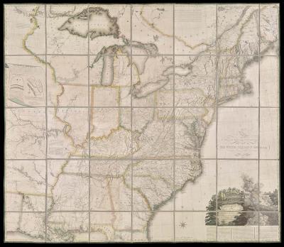
Shelton & Kensett
Amos Doolittle, (1754 -1832)
A Map of the United States and British provinces of Upper and Lower Canada with other parts adjacent by Shelton & Kensett.
Cheshire, Connecticut, 1816
Osher Collection
The first map of the United States published in The Ottoman Empire, this map was produced as part of the Cedid Atlas Tercümesi, the first Muslim-published world atlas based on European geographic knowledge and cartographic methods. Created during the reign of Sultan Selim III (1789–1807), who sought to implement reforms based on European models, the purpose of the atlas was to provide modern geographic information for students and teachers at the military engineering school and officials in the Ottoman War and Foreign Ministries. This particular plate was clearly copied from William Faden’s 1796 map of the United States.

Mahmoud Raif Efendi
[Map of the United States - title in Ottoman Turkish]
From: Cedid Atlas Tercümesi
Constantinople, 1803
Osher Collection
This beautifully executed map exemplifies many of the attributes of the great Dutch maps, including accurate geography, artistic composition, fine engraving, elegant lettering, attractive decorative imagery, and skillful hand-coloring. Production of maps such as this was a complex process involving several steps. Geographic information from earlier maps or from descriptions by explorers and travelers was carefully compiled to create a new geographic delineation. Decorative elements were created, adapted, or borrowed; many of the images and motifs were taken from pattern and emblem books, illustrated travel and voyage accounts, or other works of art. In some cases, they were simply copied directly from other maps, along with the geography. Other times, the elements were integrated into an overall design, engraved on a copper plate, printed, and then hand-colored as desired.
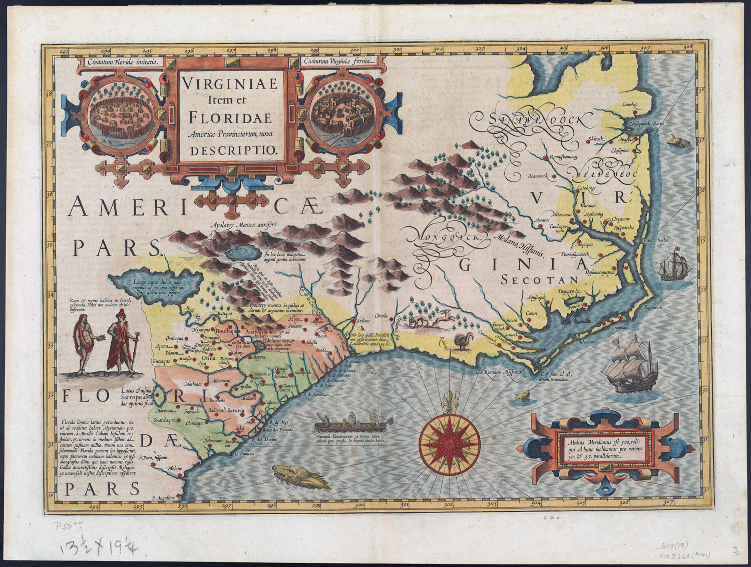
Jodocus Hondius, (1563 -1612)
Virginiae Item et Floridae Americae Provinciarum, nova Descriptio.
Amsterdam, 1619
Osher Collection
This is the first edition of this map by deputy surveyor general of Lower Canada, Joesph Bouchette Junior. Compiled from his own surveys of Lower Canada and those of Holland, Owen, Wright, Des Barres, Bayfield, and Joseph Bouchette Senior, the map shows the districts, counties and townships of Upper and Lower Canada. The recent acquisitions of the Canada Company in midwestern Ontario are indicated by symbols denoting lots of 200 acres, blocks, and land composed of both blocks and lots.
This map shows the concentrated pattern of settlements along the St. Lawrence, Lake Ontario, and Lake Erie and the undeveloped regions of northern Ontario and western Canada. There is a great deal of detail in the U.S. portions of the map, and attention is paid to the Maine boundary dispute, but only the British claim line is shown.
The Osher Map Library’s copy also contains three pasted-on pictures. The picture in the top left is “Interior of a house on the island of St Laurent,” engraved by Jean Augustin Franquelin (1798-1839) and originally appearing in Louis Choris' 1822 Picturesque voyages around the world, an account of the 1815-1818 expedition led by Otto von Kotzebue (1787-1846).
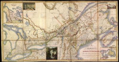
Joseph Bouchette Jr.
James Wyld, (1812-1887)
Map of Provinces of Lower and Upper Canada, Nova Scotia, New Brunswick, Newfoundland, & Prince Edward Island, with a large portion of the United States, Compiled from the latest and most approved Astronomical observations, authorities, and recent surveys, is with His Majesty's most gracious & special permission, most humbly & gratefully dedicated by His Majesty's most devoted & Loyal Subject. Joseph Bouchette Junr. Deputy Surveyor of the Province of Lower Canada.
London, 1839
Osher Collection