

The maps shown here are part of First Folio! The Book that Gave Us Shakespeare, an exhibition on display at the Portland Public Library from March 4 to April 2, 2016. To learn more about the exhibit, please visit www.portlandlibrary.com/programs-events/first-folio/.
The plays in Shakespeare’s “First Folio” embed ideas and conceptions of space and place prevalent among the nobility, gentry, and burgeoning professional and mercantile classes of late sixteenth- and early seventeenth-century Europe. Those conceptions were defined through a variety of geographical works, notably the first modern atlas—Abraham Ortelius’s wildly successful Theatrum orbis terrarum, first published in Antwerp in 1570—but also Protestant Bibles and biblical commentaries furnished with maps and the wall maps with which aristocrats and merchants often decorated their halls. Together, such works were the primary generators of concepts of space and places beyond immediate surroundings.
Shakespeare refers to maps as objects in several plays, from the opening scenes of King Lear, where the map begins the very real fracturing of the country, to Henry IV, where maps are again used to divide the land. It is even possible to identify particular maps. In Twelfth Night, Maria proclaims that Malvolio “does smile his face into more lines than is in the new map with the augmentation of the Indies”; this reference is accepted as pointing directly to Edward Wright’s world map, which served as the frontispiece to Richard Hakluyt’s Principal Navigations (1599). And the siege and taking of Rhodes in Othello seems to have drawn on the account of that city in Hakluyt’s book.
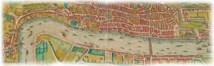
More generally, Shakespeare relied on spatial concepts that he held in common with his audiences to deepen the plots and characters of each play. The distinctive nature of cities as built environments and complex communities was enshrined in many plans and views. The Liber chronicarum (or “Nuremberg Chronicle”) of 1493 was a widely distributed early source of city views, such as those of Verona and Venice, the distant settings for Romeo and Juliet and Two Gentlemen of Verona, and The Merchant of Venice and Othello, respectively. Georg Braun and Franz Hogenberg’s Civitates orbis terrarum, whose first volume appeared in 1572, was an extremely popular and exhaustive collection of views of cities and towns around the world. Its beautiful maps and views tell the story of each city and provide an historical and allegorical context for each place and its community. Their 1572 view of London shows bull- and bear-baiting rings where the Globe Theater would later stand, together with figures in contemporary dress; overall, it gives an idea of the development of London at the time and of the effect of taxation on the development of Southwark.
The history plays depend on a shared understanding of past geography from historical maps. The ancient Roman Empire was repeatedly mapped in the sixteenth century. Theodore de Bry and Jean Jacques Boissard’s 1597 map of ancient Rome, the setting for Julius Caesar and Titus Andronicus, is similar to the city views in the Liber chronicarum and the Civitatis orbis terrarium in that it represents a general representation of a famous city from an oblique view, supposedly from atop a hill. The buildings are presented schematically and selectively, with only the most important or noteworthy displayed and each in a stylized manner, to construct ideas about the place rather than the actual layout of the city. Ortelius, in his 1579 map of the whole empire, the stage for Anthony and Cleopatra and Coriolanus, goes even further. In addition to displaying the expanse of the empire at its height, it presented portraits of Romulus and Remus, the genealogy of Roman emperors, and a short textual history of imperial conquests. This map, very typical of its time, provides us not only with a geographic representation of the vastness of the Roman Empire, complete with important cities and physical features, but also the actual and mythological history of the empire.
It is these allegorical meanings of early modern maps—how they represented the character of places both near and far—rather than their precise geographical outlines that contributed to the audience’s understanding of the settings for Shakespeare’s plays settings.
By Dr. Matthew Edney and Ian Fowler