The "Percy Map" is an impression of the "second edition, second issue" of the Jefferys-Green Map of the most Inhabited Part of New England, first issued in London in 1768. It was purchased and used by Hugh, earl Percy, future second duke of Northumberland. The donor acquired the map from dealers who had, in turn, purchased it from a May 1997 auction of the possessions of the Percy family. The auction included several other maps (see Mercator's World 2, no.5 [Sep/Oct 1997], 68-69). Until the auction, the map had resided in the Percy family's archives at Alnwick Castle. The provenance of the map is thus certain. As can be readily seen from the digital facsimile, the map itself was dissected and mounted on cloth, a common practice in the eighteenth century when map owners wanted to fold up large maps for easy handling. Indeed, all of the Percy maps in the auction were treated in the same manner.
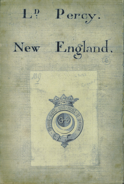
Several of the maps in the auction bear two characteristic additions on each map's verso. Those on the Map of the most Inhabited Part of New England are shown here. The staining of the cloth indicates that this was one of the two segments left exposed once the map was folded.

The first addition, in a late eighteenth-century hand, is the ink annotation "Ld. Percy | New-England." This served not only to indicate the map's owner but also to identify the map when it was folded and, presumably, placed with similarly dissected maps. The identification of "Lord Percy" dates the annotation to before 1786, when Hugh Percy inherited his father's dukedom and ceased to be known by that title (see the brief history of the Percy family in Section Ib). The similarity of these annotations across several maps strongly suggests that the maps were labeled as a set. The annotated maps all appear to pre-date Percy's return to Britain in 1777; at the very least, the annotations confirm the ownership of this map by Hugh, earl Percy.
The second addition to the verso, just below the inked lettering, is a pasted-on bookplate. This bears the Percy badge (not the family's crest or "arms"): "A crescent argent within the horns, per pale, sable and gules charged with a double manacle fesseways or" (Burke & Burke 1884, art. "Percy"). The badge is enclosed in the badge of the Order of the Garter and surmounted by a ducal coronet. This combination indicates that the bookplate is that of the duke of Northumberland: either Hugh, earl Percy -- although he did not become a knight of the Garter until 1801 -- or his father. That is, Hugh might have used his father's bookplates before 1786 or, more likely, the bookplate was added after 1802 by a librarian or archivist. More research is required on this point. Conclusions drawn from these additions are that the map was certainly owned by Hugh, earl Percy before 1786 and that it was perhaps one of a set of maps giving coverage of the colonies put together for Percy to take with him to America in 1774.
The face of the map bears a series of further annotations of roads, in pencil and ink, that supplement the map's printed roads. They indicate that the map served as a strategic planning document. Thus, however ambiguous the evidence of the additions on its verso, this map was indeed used during the Revolutionary War. We should note at this point that soon after Percy left for America, the "third edition" of the map was printed; had Percy bought the map after his return, it would most likely have been one of that edition.

