

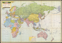
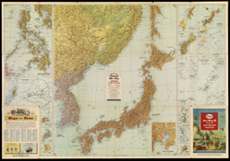
In addition to sparkling gas stations, happy traveling families, and majestic natural scenery, oil companies also portrayed the darker side of American history by including images of war. The military conflicts that most often appeared in cover art were the Revolutionary War, the Civil War, and World War II. Companies understandably chose not to dwell on the human costs of combat, but instead distributed maps that highlighted the uplifting themes of patriotism and American military might. During the 1940’s, oil companies joined the war effort and also expanded their cartographic range. Cover art of war maps printed by the oil companies during this period expressed the growing tensions abroad, and illustrated significant military events. Featuring images of allied bombing campaigns in Europe and troops storming the shores in the Pacific, these maps promoted not only the heroics of American forces, but also the pivotal role the oil industry played in ensuring victory. Road map depictions of scenes from the Revolutionary era and the Civil War often focused on poignant or dramatic events such as Cornwallis’s surrender at Yorktown and President Lincoln’s Gettysburg Address. These types of images were used to entice motorists to visit rural or historical sites that might otherwise be passed by.
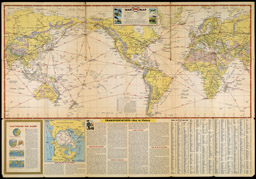
War Map featuring Transportation – The Key to Every Successful Campaign
New York: General Drafting Co., 1942
Doug Yorke Collection
Esso Marketers
War Map II featuring The World Island [and] Fortress Europe
New York: General Drafting Co., Inc., 1943
Doug Yorke Collection
Esso Marketers
War Map III featuring the Pacific Theater
New York: General Drafting Co., ca. 1944 – 1945
Doug Yorke Collection

Esso
Pennsylvania Road Map with Pictorial Guide
Convent Station, N.J.: General Drafting Co., Inc., 1952

Esso
Richmond and the Historic Richmond-Petersburg Area
Convent Station, N.J.: General Drafting Co., Inc., 1960
Doug Yorke Collection

Esso
New York Road Map with Pictorial Guide
New York: General Drafting Co., Inc., 1952
Automobile Association of America
Direct Routes to Washington, Yorktown, Virginia Beach and the South
Automobile Association of America, ca. 1931