
This 1869 map depicts four large wharves at the base of Munjoy Hill at what is now East End Beach. These proposed wharves wee part of an ambitious plan to extend the working waterfront beyond Commercial Street around the end of the peninsula. If this plan had been implemented, the residential neighborhoods and familiar landmarks such as East End Beach, Fort Allen Park and the Eastern Promenade would not exist today.

J. F. Gedney
Map of Munjoy Hill and the Adjacent Waters of
Portland Harbor, showing proposed Plan of Improvements
1869
Lithograph, 41 x 46 cm
Courtesy of Earle G. Shettleworth, Jr.
Sketch of The Completed State Pier
at Portland 1923
Courtesy of Drew Swenson
These three images [70, 71, 72] courtesy of Drew Swenson, depict the most recent reincarnation of Portland's waterfront as a gateway for luxury cruise ships. Within walking distance of the Old Port,@ it is hoped that tourists from the luxury liners will explore the city and support Portland's tourist economy.
70, 71, 72. [Ocean Gateway Project]
Three selected views of planned project
Color Laser Facsimiles
Courtesy of Drew Swenson
This 1909 transportation map presents a dramatic bird's eye view of the greater Portland metropolitan region served by a convenient inter-urban trolley system linking Brunswick, Lewiston, Old Orchard and other destinations. The growth of commuter suburbs and increased ridership of light rail was encouraged by company built terminal station attractions at Riverton Park and Cape Cottage in Cape Elizabeth. Produced by Walker Lithographers of Boston, this colorful map exemplifies the artistry which commercial printing had achieved at the turn of the century.
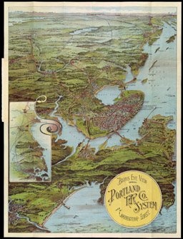
Birds Eye View Showing Portland R.R. Co. System
and Connecting Lines
Boston: Walker & Lith. & Publ. Co., 1909
Color lithograph, 69.5 x 52 cm
Osher Collection