Portland changed dramatically overnight as a result of the Great Fire of July 4, 1866. The winds were high and the tide was out when the fire began, thus creating ideal conditions for the fire to spread from west to east, devastating much of the city. The Great Fire was the worst urban fire in America at the time, sustaining losses over twelve million in today’s dollars. Unfortunately, the scale of destruction was soon to be surpassed by Chicago in1871 and Boston in 1872.
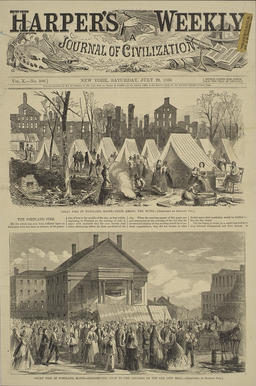
Harper's Weekly, the most widely read of the pictorial press publications, showed on its front page Portland's post-fire tent city and the soup kitchen at old City Hall in its July 26, 1866 edition.
The Portland Fire
From: Harper’s Weekly (July 28, 1866)
Wood engraving, 40 x 26 cm
Courtesy of Earle G. Shettleworth, Jr.
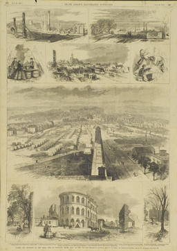
Two days later, Harper's rival Frank Leslie's, showed nine images from the Great Fire in its center spread. The central bird's eye image uses the Observatory to orient the viewer.
Frank Leslie’s Illustrated Newspaper, July 28, 1866
(six views on one page)
From: Frank Leslie’s Illustrated Newspaper (July 28, 1866: 296-297)
Wood engraving
55 x 40 cm
Courtesy of Earle G. Shettleworth, Jr.
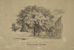
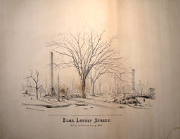
This pair [45,46] of engravings by Portland artist J. B. Hudson Jr. shows Locust Street, with and without its Elms trees, before and after the fire.
J. B. Hudson, Jr.
Elms, Locust Street Before the Fire of July 4, 1866
Portland, 1866
Lithograph, reduced facsimile
Courtesy of Earle G. Shettleworth, Jr.
Based upon the 1866 directory map of Portland, this map was produced shortly after the great fire to graphically illustrate the path of the conflagration across the center of the peninsula.
J.H. Bufford
Plan of Portland 1866
Boston & New York: Bufford Brothers, 1866
and Portland: S. B. Beckett, 1866
Lithograph, 35 x 44 cm
Courtesy of Maine Historical Society
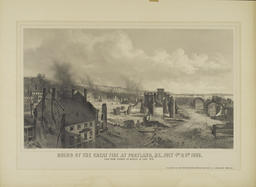
This large gray toned lithograph from Bufford's Boston lithography house, drawn by J. E. Baker, conveys the extent of the fire's destructive path in somber tones.
J. E. Baker
Ruins of the Great Fire at Portland, ME,
July 4th and 5th, 1866, View from Corner
of Middle and Free Streets
Boston & New York: Bufford Brothers, 1866
and Portland: S. B. Beckett, 1866
Lithograph, 42 x 63 cm
Private Collection
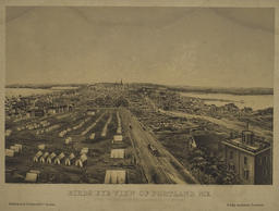
These two [49,50] images dramatically portray the devastation looking westward down Congress Street from the Observatory. While earlier topographic views depended on drawings by artists on the scene, this view is based on a photograph shown below.
J. Mayer and Co. Lithography
Birds Eye View of Portland, ME.
Taken Two Days after the Great Fire
of July 4th, 1866
Boston and Portland: B. B. Russell & Co.,
and John Hankerson, 1866
From: A photograph by Black and Case,
put in perspective by G. Bowker
Lithograph, 35 x 46 cm
Courtesy of Earle G. Shettleworth, Jr.


