

During the nineteenth century, one popular way to express civic pride was to produce commemorative prints of the city's landmark buildings. The first print to show a specific building in Portland is A View of the First Parish Meeting House published in 1825 by Portland engraver David C. Johnson. The image depicts the 1740 colonial meeting house with the addition of a tower in 1760. The familiar banneret weathervane, which is still atop the First Parish Church, is shown in this early view. This same print was later bound into the second volume of Willis' History of Portland published in 1833.

David G. Johnson
Engraving, 18 x 15.5 cm
Courtesy of Earle G. Shettleworth, Jr.
In 1832, Portland was incorporated as the first city in the state of Maine. The first City Hall was originally designed in the late Federal style. This structure was the focal point of Market Square, later renamed Monument Square. In 1832 Charles Q. Clapp transformed the building's appearance into a Greek Revival temple by removing the belfry as shown here [22]. Used for other purposes after 1860, the building retained this appearance until 1887, when it was demolished to make way for the present Civil War Monument.

T. Moore
Maine Charitable Mechanic Association Certificate
Boston, 1838
Lithograph, 32 x 35.5 cm
Courtesy of Earle G. Shettleworth, Jr.
Portland's second City Hall [24] was constructed in 1858-60 at the corner of Congress and Myrtle Streets. This was the site of the former Cumberland County Courthouse, built in 1816, which was demolished to make way for the new municipal building. Burned in the Great Fire of 1866 just six years after completion, the second City Hall's stone and brick walls were used in the rebuilding of the third City Hall, which stood on the site until its destruction by fire in 1908 [postcard #25].

W. Waud
City Hall Portland, Maine
Boston: Bricher and Russell Engravers,1860
Lithograph, 16 x 23 cm
Courtesy of Earle G. Shettleworth, Jr.

Ruins of City Hall, Portland, Maine, On Morning of Jan. 24, 1908
Postcard, 14.0 x 8.5 cm
Courtesy of Earle G. Shettleworth, Jr.
The Falmouth Hotel, which opened in July 1868, was a major symbol of the post fire reconstruction of the city. Charles A. Alexander's architectural rendering is the basis of this copper-toned lithograph. Located at the intersection of Union and Middle Streets, the building was demolished in 1963-64 [see also metal dish #29].

Charles H. Crosby Lithography
Falmouth Hotel Middle and Union Streets, Portland, Maine. 1868
Lithograph, 43 x 57 cm
Courtesy of Earle G. Shettleworth, Jr.
Portland, Me. Falmouth Hotel
Dish: unmarked engraved metal, c. 1920
Courtesy of Kenneth E. Thompson
Portland Star Match Company on the west end of Commercial Street was typical of commercial establishments along the waterfront. A major portion of this building still stands today [30, 31, 32].

George H. Walker and Co.
Portland Star Match Factory Portland, ME Lithograph, 42 x 52 cm
Private Collection
Portland Star Match Trade Card
Matches reverse of Portland Star Match Trade Card
Courtesy of Dr. Bruce Nelson
The Southeast View of Portland as seen from Cape Elizabeth (now South Portland), reveals an early view with a skyline punctuated by church spires and a busy waterfront filled with trading vessels. The town's population had grown to 10,000 when this lithograph appeared in 1833 as the foldout frontispiece in Volume II of William Willis' The History of Portland.

J. H. Bufford from a sketch by J.R. Vinton
S.E. View of Portland in 1832, Taken from Fort Preble, on Purpooduck Point
Boston: Pendleton Lithography
From: William Willis, The History of Portland,. . . Part II
(Portland: Charles Day & Co., 1833)
Hand colored reproduction, 17 x 34.5 cm
Osher Collection
Based upon photographs by George M. Howe, these two litho- graphs [34, 35] illustrate how dramatically Middle Street changed from a Federal period neighborhood into a commercial district within a fifteen year period.

George M. Howe
Middle Street Portland, ME 1863
From: William Willis, The History of Portland,. . . Second Edition (Portland: Bailey & Noyes, 1865)
Lithograph, 19.5 x 11.5 cm
Courtesy of Earle G. Shettleworth, Jr.

George M. Howe
Middle Street Portland, ME 1863
From: William Willis, The History of Portland,. . . Second Edition (Portland: Bailey & Noyes, 1865)
Lithograph, 19.5 x 11.5 cm
Courtesy of Earle G. Shettleworth, Jr.

George M. Howe. Middle Street Portland, ME 1863. From: William Willis, The History of Portland,. . . Second Edition (Portland: Bailey & Noyes, 1865). Lithograph, 19.5 x 11.5 cm. Courtesy of Earle G. Shettleworth, Jr.
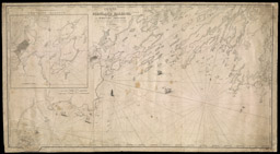
An 1805 view of the growing Federal period seaport [40] was included in a Portland Marine Society Membership Certificate. The view is evidence that the town rebuilt quickly after Mowatt destroyed it in 1775. The Old Jerusalem Meeting house is visible at the left. The 1887 Sketch of Portland Harbor [39] shows the dramatic changes taking place on both the waterfront and Back Cove during the middle years of the nineteenth century. Engraver David G. Johnson marshaled the full panoply of nautical symbols and images for this 1825 certificate [41] of the short-lived Portland Nautical Society Certificate. The copper engraving plate survives [42]. Portland's excellent deep water harbor was synonymous with commerce for much of the city's history, and both the harbor and the coast were mapped by military and commercial interests. In the 1860s the government's Coast Survey [37] was systematically recording coastal features in a series of finely detailed maps. A.W. Longfellow, the poet's brother, was in charge of recording the topography. This detail from Lemuel Moody's 1825 chart of Portland Harbor [38] offers the first large scale view since Des Barres chart of Casco Bay [see #5] some fifty years earlier. Moody was also instrumental in the organization and construction of the Portland Observatory. This large scale chart of Portland Harbor [36] was prepared by U.S. Army Engineers in 1833. Depths are indicated and the positions of buoys are shown. A diagram depicting tide tables is inset in the lower left corner.

Lt. Col. John Anderson, drawn by Lieutenant B. Poole
Map of Portland Harbor, Maine. 1833 Engraved by J.V.N. Throop
Engraving, 46 x 51 cm
Courtesy of Earle G. Shettleworth, Jr.

U.S. Coast Survey (detail)
Portland Harbor, Maine
Engraved by G. B. Metzeroth and A. Peterson, 1866
Engraving, 72 x 64.5 cm
Osher Map Library and Smith Center
for Cartographic Education
Lemuel Moody
Portland Harbour and Islands, and
Harbours Adjacent
Portland: D.G. Johnson, 1825/1828
Facsimile of inset map
Engraving, 66 x 12 cm
Osher Map Library and Smith Center
for Cartographic Education

Major Jared A Smith
Sketch of Portland Harbor, Maine, Showing the Improvements
made in 1866-86, also Projected Improvements
NY: The American Graphics Co., 1886
Lithograph, 25 x 29.5 cm
Osher Map Library and Smith Center
for Cartographic Education

James Akin (detail)
[Portland Marine Society Membership Certificate] Circa 1805
Engraving, 24.5 x 36 cm
Courtesy of Earle G. Shettleworth, Jr.
David G. Johnson
Portland Nautical Society Certificate
Circa 1825, Copperplate Engraving 30 x 22 cm
Osher Collection