

This edition of the Des Barres chart of Casco Bay, originally published in London at the beginning of the Revolution, provides the first detailed view of the Portland peninsula, then called Falmouth Neck. Though this nautical chart was produced for the British Admiralty, it accurately depicts inland details of the town's layout, bounded by India, Congress, Center and Fore streets. By the time this chart was published in 1781, much of the rebellious town illustrated here had been destroyed by Captain Mowatt. [see #6]

London: 1781
Osher Map Library and Smith Center for Cartographic Education
[The original exhibition used a colored facsimile published by Barre Publishers in 1967]
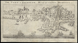
The Town of Falmouth Burnt by Capt. Moet October 1775 is the first known topographic view of the town. Executed by Boston engraver John Norman, the view shows Portland with a population of about 2000 inhabitants and some 500 buildings, 400 of which were destroyed by fire during the siege. The Old Jerusalem Meeting House of1740, illustrated on the top left with steeple, was located on Congress Street opposite the head of Temple Street, where the First Parish Church now stands. A windmill is situated on the future site of Lincoln Park.
From: Impartial History of the War in America between Great Britain and her colonies
London: Printed for R. Faulder and J. Milliken
John Norman, Engraver; Attributed to James Murray, Ca. 1780
14.5 x 28 cm
Osher Map Library and Smith Center for Cartographic Education
Falmouth Neck as it was when destroyed by Mowatt is a retrospective plan of the same events based on historical research by William Willis. This map was prepared in 1831 for Volume One of the first edition of his popular two volume work, The History of Portland.

Oct 18, 1775
From: William Willis, The History of Portland 2nd ed. (Portland: Bailey and Noyes, 1865)
Lithograph, 42 x 62 cm
Courtesy of Earle G. Shettleworth, Jr.
A Map of the City of Portland, is not only an accurate and precise map, but is embellished with detailed vignettes of many civic buildings and churches, some of which are unique representations of these structures. Created by the Portland engraver John Cullum in 1836, this map is an invaluable visual resource for urban planners and architectural historians.

John Cullum
Portland, 1836
Engraving, hand colored, 51 x 71 cm
Osher Map Library and Smith Center for Cartographic Education
The Grand Army of the Republic (GAR) was founded in 1866 by veterans of the Union Army who had served in the Civil War. This two-color lithograph provides a visual record of the nineteenth annual encampment of the GAR on Portland's Munjoy Hill in summer of 1885.

George H. Walker and Co.
Portland, ME
Boston, 1885
Lithograph, 14 x 45 cm
Courtesy of Dr. Bruce Nelson
Civil engineer James Hall created this precise record of Portland in 1837, just five years after its incorporation as Maine's first city. The key guide at the lower right lists prominent buildings which are cross referenced to their locations on map. A hand-colored version of the same map, still in the city's archives, was used to demarcate the voting wards of the city.

James Hall
Drawn by W.L. Dearborn and T. Quinby
Boston: Moore’s Lithography, 1837
Lithograph, 67 x 89 cm
Courtesy of Maine Historical Society
This view of the eastern part of the city, is a lithograph based on an 1830 Charles Codman painting depicting the 1829 encampment of Boston Rifle Rangers.

Charles Codman
Boston: Pendleton Lithography, 1830
Lithograph, 29 x 35.5 cm
Courtesy of Greater Portland Landmarks
S. H. Colesworthy, a Portland bookseller, issued this View of the Whig Pavilion on Mount Joy to commemorate a political rally on September 27, 1837. This copperplate engraving is a fine example of Portland's craftsmanship at this time.

S. H. Colesworthy
Portland, 1837
Engraving, 25 x 35 cm
Courtesy of Maine Historical Society
This exquisite three-color view of Portland was the local harbinger of the great age of topographic prints celebrating American towns and cities. The 1848 lithograph by Edwin Whitefield shows a busy harbor, a populated central peninsula, and a newly constructed bridge to Cape Elizabeth, now South Portland.

Edwin Whitefield
New York: Whitefield and Smith, 1848
Printed in colors by Jones and Newman, New York
Three color lithograph, 52 x 93 cm
Private Collection