
A California artist who turned his hand to painting, photography, and sculpting, Jo Mora also produced some of the most original pictorial maps in the United States between 1927 and 1945. At his best, his maps were characterized by great charm and whimsy. Originally published in black-and-white in 1931, Mora's map of the Grand Canyon was reissued after his death in this color version.

14. Jo Mora, Grand Canyon (1959).
Stephen J. Hornsby Collection
URL: www.oshermaps.org/map/4000164
Pictorial Maps Landmarks Search Letter Clue: V
--> View Map in New Window
Based in Spokane, Washington, the Lindgren Brothers produced a series of "hysterical maps" for tourists visiting western states and national parks during the Depression years of the 1930s. Jolly Lindgren created a recognizable cartographic brand by designing maps with blue borders, yellow ground, and figures making corny jokes. His map of the Grand Canyon is one of the most eye-catching in the series.
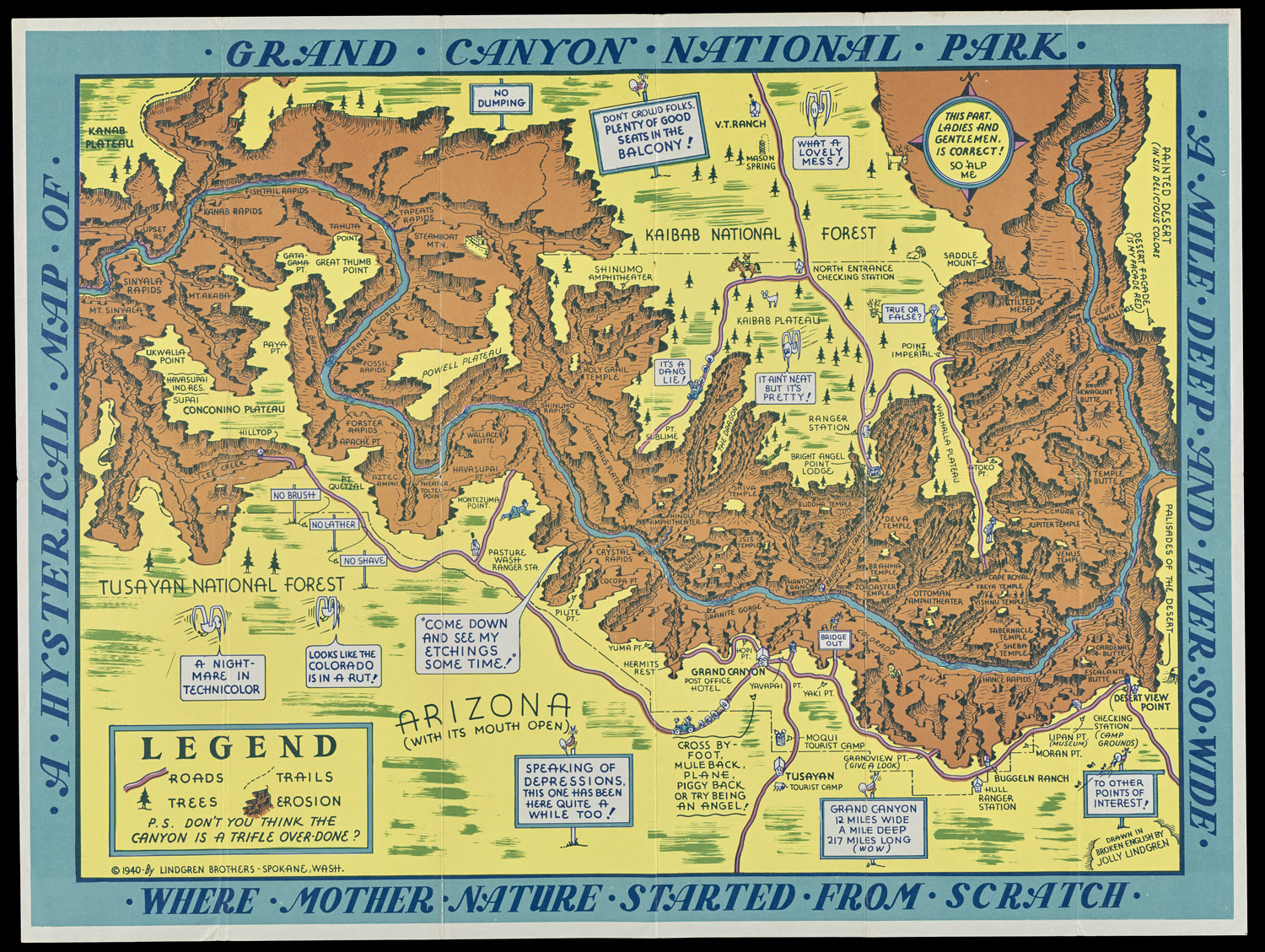
15. Jolly Lindgren, Grand Canyon National Park (1936).
Stephen J. Hornsby Collection
URL: www.oshermaps.org/map/4000165
Pictorial Maps Landmarks Search Letter Clue: L
--> View Map in New Window
Handy, a Minnesotan, designed this map of legendary hero Paul Bunyan for decorating classrooms and children's bedrooms. Paul's blue ox serves as the center of the compass rose.

16. Ray D. Handy, Paul Bunyan's Pictorial Map of the United States Depicting Some of His Deeds and Exploits (1935).
Stephen J. Hornsby Collection
URL: www.oshermaps.org/map/4000166
Pictorial Maps Landmarks Search Letter Clue: Z
--> View Map in New Window
Hammack's brag map shows the sun, personified as an orange, shining down on Los Angeles, which encompasses much of California and the Hawaiian Islands. Angelic zephyrs blow in from the Pacific, while angry hurricanes hit Florida. Canada is shown as a land of ice and snow.

17. E.S. Hammack, "Greater!" Los Angeles and the Rest of the United States as Seen thru the Sun-Kissed Glasses of a Los Angeleno (1939).
Stephen J. Hornsby Collection
URL: www.oshermaps.org/map/4000146
Pictorial Maps Landmarks Search Letter Clue: I
--> View Map in New Window
Based on an earlier black-and-white map published during Prohibition in the late 1920s, McCandlish covers this color version with cartoon figures and alcoholic place-names, including Gulp Stream and Bar Harbor. In its sales catalog, Hagstrom Company advertised the map as "a favored ornament for game rooms, fraternity houses, dormitory rooms, or private bars."
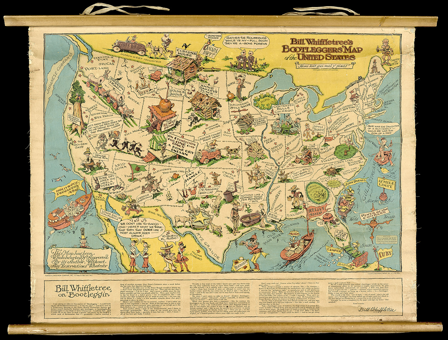
18. Edward Gerstell McCandlish, Bootlegger's Map of the United States (1944).
Osher Map Library Collection
URL: www.oshermaps.org/map/45900
Pictorial Maps Landmarks Search Letter Clue: N
--> View Map in New Window