
Although the Spanish Empire declined somewhat in political importance during the seventeenth century, it remained a powerful entity whose territories continued to provide important trading destinations. Many people throughout Europe, especially merchants and politicians, needed basic information about the location and extent of the empire's various territories. Dutch commercial cartographers provided this information in a variety of forms. Abraham Allard, for example, listed the Spanish (and Portuguese) possessions in a large block of text; he also named the ancient peoples (e.g., the Turditani of Badajoz) of the seventeen regions from which Spain and Portugal were formed (17). A few years later, Zacharias Châtelain represented the Spanish empire in Europe, the Americas, and Asia through a series of small maps (18); the descriptions gave basic historical information, including the length and breadth of each territory (measured in French common leagues, each about 2 3/4 miles).

ABRAHAM ALLARD
Dutch, 1676-1725
WEG-WYZER der LEGERTOGTEN in SPANJE en PORTUGAAL . . .
Leiden, ca. 1700
Engraving, hand colored, 50.3 x 58.7 cm.

ZACHARIAS CHÂTELAIN
Dutch, fl. 1700-1740
Carte d'Espagne et Principaux Etats Appartenans a Cette Monarchie dans les 4 Parties du Monde
From: Atlas Historique
Amsterdam, CHEZ FRANÇOIS L'HONORÉ & COMPAGNIE, 1705
Engraving, hand colored, 32.5 x 43.5 cm., with 14 insets.

THOMAS KITCHIN
British, 1718-1784
THE WEST INDIES
From: Guthrie's A new Geographical Grammar
London, [J. KNOX], ca. 1770
Engraving, hand colored, 33.8 x 37.7 cm.

GUILLAUME DE LISLE
French, 1675-1726
CARTE DE L'ISLE DE SAINT DOMINGUE . . . 1722/ca.1775
From: Atlas Nouveau . . .
Paris, JEAN COVENS & CORNEILLE MORTIER, ca. 1757
Engraving, hand colored, 47.0 x 61.2 cm.
With the decline of the Spanish empire, other European countries encroached on Spanish territories. The Caribbean islands were particularly desirable because of their rich sugar plantations. Thomas Kitchin showed the political status of the Caribbean islands in 1770 with abbreviations (e.g., "Cuba S.," "S" being for "Spanish") and with outline colors (Spanish in red, French in green, English in yellow) (19); note both Kitchin's legend and his notes about specific islands. One such note deals with the island of Hispaniola: the western half of the island was ceded by Spain to the French in 1697 as the colony of St Domingue (it became the republic of Haiti in 1790). The divided island was an obvious subject for French map makers. Guillaume de l'Isle, géographe du roi, mapped the island in great detail and with great accuracy in his general atlas (20). J. B. B. d'Anville, another French royal geographer illustrated the island for an historical text; as Columbus had first landed on Hispaniola, his coat-of-arms which feature a map of the Caribbean was included (21).

JEAN BAPTISTE BOURGUIGNON D'ANVILLE
French, 1697-1782
L'ISLE ESPANGNOLE SOUS LE NOM INDIEN D'HAYTI
From: Pierre François Xavier de Charlevoix, HISTOIRE DE L'ISLE ESPAGNOLE . . .
Paris, FRANÇOIS DIDOT, 1731
Engraving, 20.0 x 29.4 cm.
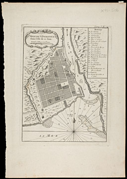
ACQUES NICOLAS BELLIN
French, 1703-1772
VILLE DE S DOMINGUE dans l'isle de ce Nom.
From: LE PETIT ATLAS MARITIME RECUEIL DE CARTES ET PLANS . . .
Paris, 1764
Engraving, 16.2 x 21.7 cm.
A further subject of the French mapping of Hispaniola was the island's principal town, also called St Domingue, which lay in the portion of the island under Spanish rule; it is now known as Santo Domingo, capital of the Dominican republic. Bellin's map identified the key locations in the town, such as the cathedral (the first built in the New World, "B"), and the Casa del Cordón (the House of Cord, built in 1509, the oldest surviving European building in the New World, "M") (22). The smaller and less detailed town map, by Manesson-Mallet, comes from the German edition of his 17th-century travel guide to Europe and the New World.

ALLAIN MANESSON-MALLET
French, 1630-1706
der Grundriss von der Stadt dee Heyl: Dominicus: Le plan de l'Lsle de ST. JAN de PTO. RICO . . . 1683/1684
From: Die Fortsetzung des alten und neuen Europa . . . und America, vol. 5 of Beschreibung des ganzen Welt-Kreisses . . . In fünff theile verfasset
Frankfurt am Main, JOHANN DAVID ZUNNERS, 1684
Engraving, 10.7 x 14.7 cm.