

An allegory presents one subject in the guise of another, often using symbols or imaginary figures to portray abstract ideas, attributes, emotions, concepts, or parts of the universe. It is an effective metaphorical device, and numerous examples of allegorical representation may be found in literature and fine art. Classical writing, scriptural commentaries, and Renaissance art are particularly rich in allegory.
In common with other forms of art, map imagery is frequently allegorical in nature and rooted in classical sources. Symbolism related to the number four was a common theme: the four cardinal directions, the four winds, the four seasons, the four classical elements (fire, air, water, and earth), and the four parts of the earth (Europe, Asia, Africa and the Antipodes ~ the latter eventually replaced by America). Personification of these themes became a common feature of maps and achieved the status of standardized representations. In particular, allegorical representation of the continents became a favorite motif for title pages of atlases and borders of maps.
Ortelius's Theatrum Orbis Terrarum of 1570 was the first "modern" printed atlas and served as the model for future works of its kind. The title page, shown here, uses allegorical images of the continents to announce that the "four parts of the world" are encompassed within the atlas. Furthermore, the design proclaims the clear message that Europe is the supreme continent; she is positioned at the top in the form of an enthroned Christian monarch with gold crown, orb, and scepter, receiving homage from the other continents. On the left, Asia is depicted as an elaborately dressed Oriental princess holding a censer. Africa, on the right, is a scantily clad dark-skinned woman holding a sprig of balsam, perhaps offered in tribute. At the bottom, an armed Amazonian warrior represents America; the severed head symbolizes cannibalism.

Item 1
Abraham Ortelius
Flemish, 1527-1598
Title page from Theatrum Orbis Terrarum
Antwerp, 1570
Engraving, hand colored
Osher Collection
This beautifully engraved map appeared in an early Dutch book on navigation to the East and West Indies, and its imagery is a complex mixture of allegory and natural history. The border decorations consist largely of personifications of the continents, set against landscapes depicting their respective terrains, fauna, flora, and scattered inhabitants. The background renditions are inaccurate, indicating that the artist was dependent on hearsay and ambiguous reports rather than first-hand observation. At the upper left, Empress Europa sits on a globe, holding her usual scepter and cornucopia, surveying a coastal scene with offshore fleet, mountain-top castles, various domestic animals, and wild bears. Asia, at the upper right, is seated on a camel and holds a censer; the church and castle in the background are European in style; the giraffe and rhinoceros are displaced from their normal habitat. At the lower left, America is seated on an armadillo, holding an arrow and a European style battle-ax; Indians in the background are hunting and engaging in cannibalism. Africa, at the lower right, sits on a crocodile and holds a snake in her left hand and a leafy branch in her right; recognizable animals include lions, camels, and elephants; there are pyramids in the background.
Item 3
Jan Baptist Vrients
Flemish, 1552-1612
Orbis Terrae Compendiosa Descriptio
From: Jan Huygen van Linschoten, Itinerario
Antwerp, 1596
Engraving
Osher Collection
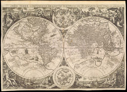
The design of this map is extraordinary in several respects. The unusual geographic projection emphasizes the fact that the surface of the earth is predominantly water. California is depicted as a large island. There are two distinctive sets of allegorical representations of the continents, one occupying the upper corners and a second surrounding the title cartouche at the top center. Europa is depicted in two strikingly different configurations. To the right of the title cartouche, she is seen in her usual regal form; in the upper left corner, she is portrayed as the mythological princess being abducted by Jupiter in the form of a bull. America is likewise delineated in two vastly different fashions. At the upper right, she is an Indian warrior and probable cannibal; to the left of the title cartouche, she is a mother nursing an infant. The array of commercial images and the blatant advertisement at the bottom of the map provide an incongruous reminder that mapmaking in eighteenth-century England was, after all, a business.

Item 4
Charles Price
English, active 1680-1720
A New and Correct Map of the World
London, 1714
Engraving, hand colored
Osher Collection
This map exemplifies the combination of elegant design, skillful engraving, and artistic hand coloring characteristic of seventeenth-century Dutch cartography. Current geographic knowledge of the world is displayed in two hemispheres. Diagrams at the top and bottom center illustrate concepts of the universe according to Copernicus and Ptolemy, respectively. The decorative borders contain conventional allegorical representations of the continents; Europe, in the upper left corner, is again seen as the dominant figure with symbols of her cultural and scientific superiority. The background landscapes portray indigenous animals and, in the case of America (lower right), natives engaged in torch-fishing. The map thus conveys information in the realms of geography, astronomy, natural history, ethnography, and mythology, and does so in an aesthetically pleasing fashion.

Item 5
Nicolas Visscher
Dutch, 1618-1679
Orbis Terrarum Tabula Recens Emendata et in Lucent Edita
From a Dutch Bible
Amsterdam, 1663
Engraving, hand colored
Osher Collection
The elaborate design of this title page is reminiscent of the previous Blaeu title page [# 2], with celestial and cartographic motifs above and personifications of the continents below. The allegorical figures have their usual attributes and are surrounded by animals. In the case of Europe (lower left), the bulls fulfill a dual role - as the domesticated animal and as the symbol of the classical myth illustrated on the Price map [# 4]. The remaining animals are, for the most part, readily recognizable as indigenous to their continents. Some, however, are inaccurately portrayed, as in the case of the ferocious looking horned armadillo at the feet of America.

Item 6
Jan Jansson
Dutch, 1588-1664
Title page from Nouvel Atlas ou Theatre du Monde
Amsterdam, 1667
Engraving, hand colored
Smith Collection
This title page is from one of the volumes of Blaeu's Atlas Major, widely regarded as the finest atlas ever published. The beautifully engraved architectural design provides a framework for the title and decorative elements. In keeping with the contents of the atlas, the elaborate heraldic arms at the top contain royal emblems of Portugal, the armorial bearings of Isabella of Castile and Ferdinand of Aragon, the pomegranate of Granada, and the Order of the Golden Fleece. The continents, portrayed along the sides, are personified in conventional form except for the Phoenix, symbolizing immortality, at Asia's feet.
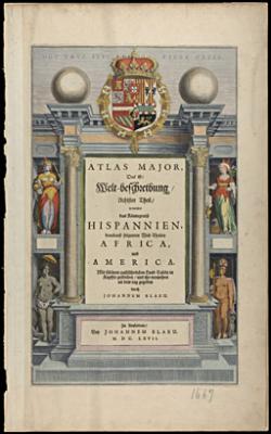
Item 7
Joan Blaeu
Dutch, 1596-1673
Title page from Atlas Major
Amsterdam, 1667
Engraving, hand colored with gold highlights
Smith Collection
This engraving presents a tableau in the style of classical mythology, paying tribute to the accomplishments of European seafarers in revealing the other continents and their treasures. Africa, Asia, and America are portrayed with their usual attributes. The central figure is the goddess Fortune, mistress of the seas, wearing a crown consisting of ships' prows. In her right hand she holds a billowing sail symbolizing the inconstancy of the winds, and in her left hand she holds a rudder signifying her mastery of navigation. Mercury hovers overhead in his role as god of commerce and patron of travellers.

Item 8
Bernard Picart
French, 1673-1733
Untitled frontispiece from H.A. Chatelain, Atlas Historique...
Amsterdam, 1719
Engraving
Smith Collection
In this early woodcut, the artist literally personifies Europe by using its geographic outline to create the image of a queen or empress. With west at the top, geographic features are cleverly incorporated into the likeness: the Iberian peninsula forms the head, with the Pyrenees Mountains as a necklace; Italy is the right arm and Denmark the left; Sicily is the orb, and Great Britain forms a pennant attached to the scepter; mountain ranges, forests, and rivers decorate the royal gown.

Item 9
Sebastian Munster
German, 1489-1552
Untitled [Europe in the form of a woman]
Basle, 1545
Woodcut
Osher Collection