
The United States of America laid down From the best Authorities, Agreeable to the Peace of 1783 The political independence of the United States was celebrated in several maps published during the Revolution and, like this one, during the Anglo-American peace negotiations. This map weds the territory of the new republic to its high ideals, expressed in the allegorical title-cartouche. On the left of the cartouche, the Revolution’s military architect, George Washington, ushers forward Liberty. On the right, Wisdom and Justice guide its political architect, Benjamin Franklin. Over all flies the new Stars and Stripes, heralded by an angel who appears about to place an imperial wreath atop the flag pole. A simple, compelling, and idealized political statement emerges about what the moral and geographical character of the United States should be, from the perspective of a British supporter of the Revolution. This kind of imagery neatly demonstrates the manner in which maps convey political and social as well as geographical meanings.
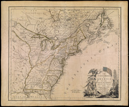
John Wallis (English., fl. 1780-1800)
The United States of America laid down From the best Authorities, Agreeable to the Peace of 1783
Engraving, hand-colored, 46.0cm x 55.0cm London, 1783
Osher Collection
This atlas frontispiece, first published in J. H. Colton’s American Atlas (1855), illustrates the potency of Manifest Destiny in the formation of a national identity for the United States. It depicts the westward expansion of the U.S. from the East (background), across the Great Plains (center ground), to the first settlements hewn from the wooded slopes of the Rockies (foreground). A group of Native Americans—depicted in a highly romanticized manner, as befits an image originally prepared by a German artist for a European audience—witness the inexorable advancement of American civilization, even as they are excluded from it. Carl Emil Doepler’s image reminds us that the identity constructed for the United States in the nineteenth century by maps and atlases was overwhelmingly one of a nation of Northern European-descended Protestant men.
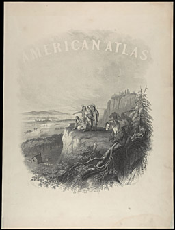
Carl Emil Doepler (German, 1824-1905)
Joseph Hutchins Colton (American, 1800-1893)
[Frontispiece]
Etching transferred to lithograph, 34.0cm x 28.0cm
From: Johnson's New Illustrated (Steel Plate) Family Atlas (New York: Johnson and Ward, 1865)
Osher Collection

James Wilson (American, 1763-1855)
A New American Terrestrial Globe
Engraving, hand-colored, 13" (33cm) diameter
Bradford, VT, 1811
Osher Collection

W. B. Annin (American, d. 1829)
Gilman Joslin (American, 1804-ca. 1886)
Joslin's Six Inch Terrestrial Globe, Containing the Latest Discoveries
Engraving, hand-colored, 6" (15.25cm) diameter
Boston, 1868
Osher Collection
James Wilson, a Vermont farmer and blacksmith, made the first globes in the United States in about 1810. The larger globe displayed here is his first dated one (1811) [item 3]. Although useful devices for classrooms and libraries, globes were not an important form of geographical representation in nineteenth-century America. Thus, after first publishing his paired terrestrial and celestial globes in the 1820s, Gilman Joslin could continue to simply reissue them with few changes for many decades [items 4-5]. Downplaying their connections with the rest of the world, Americans expressed their political and nationalist desires through their wall maps and atlases.

W. B. Annin (American, d. 1829)
Gilman Joslin (American, 1804-ca. 1886)
Joslin's Six Inch Celestial Globe, From the best Authorities
Engraving, hand-colored, 6" (15.25cm) diameter
Boston, 1840
Osher Collection